Emily restrengthens to a Cat. 4
 Summary by Jordan Golson, updated by Bryan Woods: As of the 11AM EDT Advisory, Hurricane Emily had restrengthened to a strong Category Four hurricane with winds of 150mph and a central pressure that has dropped to 946mb according to reconnaissance aircraft. Emily is moving to the WNW at near 18mph. Hurricane Emily is approaching Category 5 intensity. Emily now has the strongest winds AND lowest pressure of any hurricane ever in June and July. This title was previously held for only a matter of days by Hurricane Dennis. Some fluctuations in intensity are forecast for the next day or so, as is common with major hurricanes. Hurricane Emily could easilly reach Category 5 strength within the next day. The swath of hurricane force winds seems to be growing, especially in a rain band that has formed to the north of Emily. Hurricane warnings are up for both islands. Hurricane watches have also been posted for the Yucatan Peninsula.
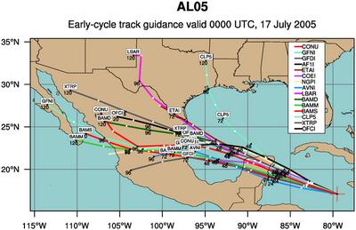
Forecast by Bryan Woods: The model guidance seems to have locked-on to a track across the Yucatan and entering the Gulf of Mexico where Emily should restrengthen into a major hurricane, probably a Category 3. For the latest model track forecasts, see below.
Satellite imagery clearly shows the large rain band still wrapped around the north side of the hurricane. It is in this band that the hurricane hunter earlier discovered hurricane force winds over 100 miles outside of the eye of the storm. For the whole day so far, Emily's central core has remained intact and looked very solid. She currently has a very well defined eye and looks extremely healthy. Click on this image below and expand out the shot. Just look at the form of the eye! The latest Dvorak IR shot may be starting to show signs of a double eyewall and the start of a replacement cycle.
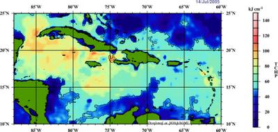
In regards to intensity, check out the map below of Tropical Cyclone Heat Potential (TCHP). You can see that Hurricane Emily is clearly moving into an area full of energy. If the wind shear can continue to stay down like it has done recently, further strengthening is a very real possibility. However, yesterday provided a lot of shear from a upper low to the west that brought Emily down to a Cat. 2 storm for a while. Fluctuation in intensity are expected as Hurricane Emily undergoes natural eyewall replacement cycles.


