<body><script type="text/javascript"> function setAttributeOnload(object, attribute, val) { if(window.addEventListener) { window.addEventListener('load', function(){ object[attribute] = val; }, false); } else { window.attachEvent('onload', function(){ object[attribute] = val; }); } } </script> <div id="navbar-iframe-container"></div> <script type="text/javascript" src="https://apis.google.com/js/platform.js"></script> <script type="text/javascript"> gapi.load("gapi.iframes:gapi.iframes.style.bubble", function() { if (gapi.iframes && gapi.iframes.getContext) { gapi.iframes.getContext().openChild({ url: 'https://www.blogger.com/navbar/12987919?origin\x3dhttps://stormtrack.blogspot.com', where: document.getElementById("navbar-iframe-container"), id: "navbar-iframe", messageHandlersFilter: gapi.iframes.CROSS_ORIGIN_IFRAMES_FILTER, messageHandlers: { 'blogger-ping': function() {} } }); } }); </script>

StormTrack has moved: http://thestormtrack.com/


September 10, 2005

Moving Day

StormTrack has moved to it's new home at http://thestormtrack.com/.
This will be the last post on Blogger, but all the old posts will stay up.
Change your bookmarks!

August 29, 2005

Katrina weakens a bit more, New Orleans Under the Gun


Katrina has weakened somewhat to a strong category 4 hurricane with winds of 155 mph and 910mb central pressure. It's a waiting game to see if she wobbles a bit and spares a direct hit on New Orleans proper and just how bad she is when she moves ashore.

August 28, 2005

Katrina weakens slightly, New Orleans still screwed.


The storm has slowed down and is still moving NNW at 9 knots. It is tracking just to the west of New Orleans proper and this is a bad thing. Latest observations show the storm at 160mph and 904mb which is interesting. The drop in winds is not surprising and in fact the earlier 175mph numbers may have been incorrect. These numbers were based on flight level winds from Hurricane Hunter aircraft and looking back at the data the National Hurricane Center has revised the windspeeds lower. This is not to say that the storm is not strong. IT IS. A sustained pressure of 904mb is incredibly impressive and significantly stronger than Andrew and really any other hurricane we have ever seen in our lifetimes.

Apparently a eyewall replacement cycle is happening which could cause weakening within the storm, but will result in a widening wind field which really is a wash. Winds may be slightly decreased near the eyewall but it really does not matter since the winds are SO strong.

Video from NOLA

Streaming video from WWL-TV CBS New Orleans

Katrina continues to strengthen,


According to the latest VORTEX data message Katrina has strengthened to 902mb and 184mph.

"I do not want to create a panic, but..." - Mayor of New Orleans

Bigger than Camille, Time to Pray


A DROP IN THE EYE
GAVE A CENTRAL PRESSURE OF 907 MB. KATRINA IS COMPARABLE IN
INTENSITY TO HURRICANE CAMILLE OF 1969...ONLY LARGER.


Andrew hit with a central pressure of 922mb.

Camille hit with a central pressure of 909mb.

Right now, Katrina is at 907mb. If she stays anywhere around here (and there is NO reason to think she will weaken dramatically other than natural weakening of a big storm) it will be absolutely devastating.

Winds of 175, which are more than enough to make plans take off in. SUSTAINED WINDS.

For comparison, this is similar to a F3 tornado.

August 27, 2005

Katrina strengthens, New Orleans battens down

Watches and Warnings are up for the Gulf Coast in anticipation of a Monday landfall of Hurricane Katrina.

The latest advisory shows a central pressure of 939mb and maximum sustained winds at 115 mph making her a borderline Category 3 hurricane. SHIPS intensity model is still calling for a STRONG category 4 landfall between 140 and 150mph. Models are tightening up with a hit around New Orleans proper.

This is no joke, this would be a completely devastating hurricane strike, with absolutely no precedent in the United States, not even compared to Andrew. New Orleans is anywhere from 0-30 feet below sea level (with 0 being at the Mississippi River).

Here is a quote from the PBS show NOW
WALTER MAESTRI: New Orleans is, if you think about it, it's a soup bowl. Think of a soup bowl. And the soup bowl-- the high edges of the soup bowl-- is the Mississippi River. It's amazing to say, but the highest elevation in the city of New Orleans is at the Mississippi River.

DANIEL ZWERDLING: Maestri says, imagine what happens if a hurricane like Andrew comes raging up from the Gulf:

WALTER MAESTRI: The hurricane is spinning counter-clockwise. It's been pushing in front of it water from the Gulf of Mexico for days. It's now got a wall of water in front of it some 30, 40 feet high. As it approaches the levies of the-- the-- that surround the city, it tops those levees. As the storm continues to pass over. Now Lake Ponchetrain, that water from Lake Ponchartrain is now pushed on to that - those population which has been fleeing from the western side and everybody's caught in the middle. The bowl now completely fills. And we've now got the entire community underwater some 20, 30 feet underwater. Everything is lost.

DANIEL ZWERDLING: Remember the levees which the Army built, to hold smaller floods out of the bowl? Maestri says now those levees would doom the city. Because they'd trap the water in.

WALTER MAESTRI: It's going to look like a massive shipwreck. There's going to be-- there's going to be, you know-- everything that that the water has carried in is going to be there. Alligators, moccasins, you know every kind of rodent that you could think of.

All of your sewage treatment plants are under water. And of course the material is flowing free in the community. Disease becomes a distinct possibility now. The petrochemicals that are produced all up and down the Mississippi River --much of that has floated into this bowl. I mean this has become, you know, the biggest toxic waste dump in the world now. Is the city of New Orleans because of what has happened.

If you, or anyone you know is in or around New Orleans, I cannot strongly urge you enough to leave the city and seek higher ground. There is simply too much of a danger of extreme and prolonged flooding to stay in the city. Even a skirting hit would do serious damage to life and property and it simply is not worth it to stay.

If Jim Cantore shows up on your doorstep, it is going to get interesting.
July 17, 2005

Emily Nearing Yucatan

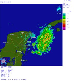
Hurricane Emily is past the Cayman's and is approaching the Yucatan Peninsula. Intensity remains 135mph as it has for the better part of the past 24 hours but central pressure is up to 955mb and she is showing some signs of deterioration. The eye is less distinct in satellite shots and the overall cloud pattern has become very little ragged.

The fact that the eyewall of Emily is showing up on the radar hours ago is very impressive. Radar beams travel out at a 0.5 degree elevation and the Earth also curves out from underneath the beam. For an eyewall to show up so far a way is a sign of a powerful hurricane. Of course, at this point the hurricane seems to have knocked out the radar in Cancun.


She is still over very warm water which is keeping her strength up and no changes in strength are forecast other than minor fluctuations which are to be expected in a hurricane this size. Emily will make landfall shortly and will then restrengthen into a Major Hurricane (Cat 3 or Above) once she re-enters the Gulf of Mexico. After that is less clear, but the models are calling for a hit on Northern Mexico just south of the US/Mexico border.


For more info: Forecast Map, Satellite Images, Advisories, Flight Recon Data
Tracking God's Fury:
ATLANTIC
Tropical Storm Maria
Tropical Storm Nate
Hurricane Ophelia
EASTERN PACIFIC
  • None
  • --
    Ask Bryan:
    What steers hurricanes?
    What is eyewall replacement?
    --
    Contributors:
    Jordan Golson
    Bryan Woods
    --