<body><script type="text/javascript"> function setAttributeOnload(object, attribute, val) { if(window.addEventListener) { window.addEventListener('load', function(){ object[attribute] = val; }, false); } else { window.attachEvent('onload', function(){ object[attribute] = val; }); } } </script> <div id="navbar-iframe-container"></div> <script type="text/javascript" src="https://apis.google.com/js/platform.js"></script> <script type="text/javascript"> gapi.load("gapi.iframes:gapi.iframes.style.bubble", function() { if (gapi.iframes && gapi.iframes.getContext) { gapi.iframes.getContext().openChild({ url: 'https://www.blogger.com/navbar/12987919?origin\x3dhttp://stormtrack.blogspot.com', where: document.getElementById("navbar-iframe-container"), id: "navbar-iframe", messageHandlersFilter: gapi.iframes.CROSS_ORIGIN_IFRAMES_FILTER, messageHandlers: { 'blogger-ping': function() {} } }); } }); </script>

StormTrack has moved: http://thestormtrack.com/


May 23, 2005

Severe Weather Update - 235AM EDT


A severe thunderstorm watch was issued by the SPC for portions of northwestern Arkansas, south central and southeastern Kansas, southwestern Missouri and north central and northeastern Oklahoma.

Conditions are right for severe thunderstorm development and hail to 2.5 inches in diameter, wind gusts to 70 mph and dangerous lightning.

The watch is in effect until 5AM EDT.

Earlier this evening a Tornado Warning was issued for Cherokee County in east central Oklahoma and Wagoner County in northeast Oklahoma.
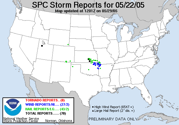

No tornados formed but golf-ball sized hail was reported in several counties in Kansas and New Mexico and winds up to 80mph in Cowley County, Kansas.
Tracking God's Fury:
ATLANTIC
Tropical Storm Maria
Tropical Storm Nate
Hurricane Ophelia
EASTERN PACIFIC
  • None
  • --
    Ask Bryan:
    What steers hurricanes?
    What is eyewall replacement?
    --
    Contributors:
    Jordan Golson
    Bryan Woods
    --