<body><script type="text/javascript"> function setAttributeOnload(object, attribute, val) { if(window.addEventListener) { window.addEventListener('load', function(){ object[attribute] = val; }, false); } else { window.attachEvent('onload', function(){ object[attribute] = val; }); } } </script> <div id="navbar-iframe-container"></div> <script type="text/javascript" src="https://apis.google.com/js/platform.js"></script> <script type="text/javascript"> gapi.load("gapi.iframes:gapi.iframes.style.bubble", function() { if (gapi.iframes && gapi.iframes.getContext) { gapi.iframes.getContext().openChild({ url: 'https://www.blogger.com/navbar.g?targetBlogID\x3d12987919\x26blogName\x3dStormTrack\x26publishMode\x3dPUBLISH_MODE_BLOGSPOT\x26navbarType\x3dSILVER\x26layoutType\x3dCLASSIC\x26searchRoot\x3dhttps://stormtrack.blogspot.com/search\x26blogLocale\x3den_US\x26v\x3d2\x26homepageUrl\x3dhttp://stormtrack.blogspot.com/\x26vt\x3d-6411802427838227869', where: document.getElementById("navbar-iframe-container"), id: "navbar-iframe" }); } }); </script>

StormTrack has moved: http://thestormtrack.com/


July 17, 2005

Emily Nearing Yucatan

Hurricane Emily is past the Cayman's and is approaching the Yucatan Peninsula. Intensity remains 135mph as it has for the better part of the past 24 hours but central pressure is up to 955mb and she is showing some signs of deterioration. The eye is less distinct in satellite shots and the overall cloud pattern has become very little ragged.

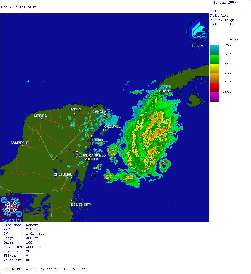
The fact that the eyewall of Emily is showing up on the radar hours ago is very impressive. Radar beams travel out at a 0.5 degree elevation and the Earth also curves out from underneath the beam. For an eyewall to show up so far a way is a sign of a powerful hurricane. Of course, at this point the hurricane seems to have knocked out the radar in Cancun.


She is still over very warm water which is keeping her strength up and no changes in strength are forecast other than minor fluctuations which are to be expected in a hurricane this size. Emily will make landfall shortly and will then restrengthen into a Major Hurricane (Cat 3 or Above) once she re-enters the Gulf of Mexico. After that is less clear, but the models are calling for a hit on Northern Mexico just south of the US/Mexico border.


For more info: Forecast Map, Satellite Images, Advisories, Flight Recon Data

July 16, 2005

Emily restrengthens to a Cat. 4

Summary by Jordan Golson, updated by Bryan Woods: As of the 11AM EDT Advisory, Hurricane Emily had restrengthened to a strong Category Four hurricane with winds of 150mph and a central pressure that has dropped to 946mb according to reconnaissance aircraft. Emily is moving to the WNW at near 18mph. Hurricane Emily is approaching Category 5 intensity. Emily now has the strongest winds AND lowest pressure of any hurricane ever in June and July. This title was previously held for only a matter of days by Hurricane Dennis. Some fluctuations in intensity are forecast for the next day or so, as is common with major hurricanes. Hurricane Emily could easilly reach Category 5 strength within the next day. The swath of hurricane force winds seems to be growing, especially in a rain band that has formed to the north of Emily. Hurricane warnings are up for both islands. Hurricane watches have also been posted for the Yucatan Peninsula.


Forecast by Bryan Woods: The model guidance seems to have locked-on to a track across the Yucatan and entering the Gulf of Mexico where Emily should restrengthen into a major hurricane, probably a Category 3. For the latest model track forecasts, see below.


Satellite imagery clearly shows the large rain band still wrapped around the north side of the hurricane. It is in this band that the hurricane hunter earlier discovered hurricane force winds over 100 miles outside of the eye of the storm. For the whole day so far, Emily's central core has remained intact and looked very solid. She currently has a very well defined eye and looks extremely healthy. Click on this image below and expand out the shot. Just look at the form of the eye! The latest Dvorak IR shot may be starting to show signs of a double eyewall and the start of a replacement cycle.


In regards to intensity, check out the map below of Tropical Cyclone Heat Potential (TCHP). You can see that Hurricane Emily is clearly moving into an area full of energy. If the wind shear can continue to stay down like it has done recently, further strengthening is a very real possibility. However, yesterday provided a lot of shear from a upper low to the west that brought Emily down to a Cat. 2 storm for a while. Fluctuation in intensity are expected as Hurricane Emily undergoes natural eyewall replacement cycles.

July 14, 2005

From the 'Oh Crap' dept: BP Works to Right $1 Billion Oil Platform

From the Associated Press:
NEW ORLEANS - BP worked Wednesday to right a $1 billion petroleum platform found listing in the deepwater Gulf of Mexico after Hurricane Dennis.

A cause had not been determined, said BP spokesman Ronnie Chappell in Houston. On Tuesday, after power was restored and crews were able to board the Thunder Horse platform, information from data recorders was sent to the shore for analysis, Chappell said.


"It's a history of the status of the equipment and actions taken by the operators, prior to the evacuation," Chappell said. "It will also provide information on what happened on the vessel after the people were removed last week."

Thunder Horse, the largest platform in the Gulf of Mexico, is the center of the Thunder Horse field, located about 150 miles southeast of New Orleans in about 6,000 feet of water. Until the accident, BP expected it to begin producing oil — as much as 240,000 barrels per day — in late 2005. Exxon Mobil Corp. is a partner in the project.
For more information...

July 10, 2005

Tropical Depression Five (Emily?) forms

Tropical Depression Five has formed in the Atlantic. It is expected to strengthen to Tropical Storm Emily by tomorrow making the fifth named storm of the season... and it isn't even July 15th yet.

It is a very remote threat to the US Mainland right now, but it is heading in the general direction of the Lesser Antilles. We will know more in the coming days.

Addendum by Weatherman Bryan: The GFDL model brings "Emily" up to 112 kts in 120 hours. Just thought I'd let you chew on that.

Dennis rapidly losing steam


Dennis has been downgraded to a tropical storm as of the 9PM EDT advisory. He has sustained winds of 60mph making him a still formidable entity with the ability to blow down more tree limbs and power lines. Pressure has risen to 972mb and he should become a tropical depression sometime tomorrow (winds below 39mph).

We will be bringing you pictures of the damage tomorrow after I have a chance to collect some. If you have any photos that you would like to send us, please email them to severestorm@gmail.com.

Minute-by-Minute Tracking

434pm edt: The next advisory will show Dennis with a rising minimum central pressure at 950mb, sustained winds of 103mph and gusts to 125mph. He's going in and he's going hard. He will continue to be a hurricane for perhaps the next 6-12 hours. We will see how quickly he dies down.

336pm edt: Hurricane Dennis has officially made landfall with the storm's eye hitting between Navarre Beach and Pensacola Beach.

327pm edt: Without a doubt the worst of Hurricane Dennis is being felt from Navarre Beach over to Ft. Walton Beach. I expect that we will see serious damage in this area which was already pounded by Hurricane Ivan last year. The weakening we are seeing is obviously related to a hurricane making landfall. If you think that this damage is bad, you should think of what Cuba must have felt.

319pm edt: The latest Advisory confirms the central pressure rise to 943mb and drops sustained windspeed down to 120mph which is a weak category 3. This storm really has died out (comparatively) in the past 6 hours.

242pm edt: Vortex reports from the latest Hurricane Hunter flight report central pressure has risen sharply to 943mb.

209pm edt: Hurricane force winds are anticipated to last 100 miles inland.

205pm edt: The latest position advisory reports the storm is 40 miles southeast of Pensacola. 2-3 hours for landfall. The storm is moving approximately 18 miles an hour.

201pm edt: Pensacola Naval Air Station reports sustained winds of 40mph which is Tropical Storm speeds and gusts to 51.

Current Images

Clockwise from top left: Mobile, AL Radar, 5-Day Track Map, Visible Satellite, Infrared Satellite. Click the images for larger view.

HURR DENNIS Update -- UPDATE 430AM

UPDATE 430AM EDT: The latest Vortex Data Message from Air Force Hurricane Hunter Aircraft at 357AM EDT shows minimum pressure has continuted to drop quickly to 932mb. Maximum Sustained Winds are at 145mph with gusts to 178MPH.

I CANNOT stress enough how strong this storm is. As of right now it is as strong wind wise as Andrew was and is almost as close in central pressure. This is a massive devastating storm and may be one of the largest to hit the US Mainland in our lifetimes.

WKRG-CBS in Pensacola is reporting that local power companies in Florida and Alabama are warning that some communities could be without power for WEEKS. There are hundreds of power crews waiting in the wings to start repairing the damage.

I was looking at the most intense hurricanes to strike the US and this storm is up there. In terms of central pressure, this storm ties Hurricane Hugo in 1989 and just under Hurricane Andrew. THere is still time for Dennis to strengthen -- or weaken -- as it moves closer to shore and we will be watching this closely all morning for you.

If anyone reading this is in the Mobile / Biloxi / Pensacola area PLEASE GET OUT NOW. There is no reason that anyone should be anywhere near the ocean when this storm moves ashore. I cannot emphasize this enough. This is going to be a major disaster when the storm comes ashore.

Essentials from the latest advisory follows:
REPORTS FROM AN AIR FORCE RESERVE HURRICANE HUNTER AIRCRAFT INDICATE THAT MAXIMUM SUSTAINED WINDS ARE NOW NEAR 145 MPH... WITH HIGHER GUSTS. DENNIS IS A CATEGORY FOUR HURRICANE ON THE SAFFIR-SIMPSON SCALE. SOME FLUCTUATIONS IN STRENGTH ARE LIKELY BEFORE LANDFALL.

AN AIR FORCE HURRICANE HUNTER PLANE RECENTLY REPORTED A MINIMUM CENTRAL PRESSURE OF 934 MB...27.58 INCHES.

STORM SURGE FLOODING OF 14 TO 17 FEET ABOVE NORMAL TIDE LEVELS... ACCOMPANIED BY LARGE AND DANGEROUS BATTERING WAVES... IS POSSIBLE NEAR AND TO THE EAST OF WHERE THE CENTER OF DENNIS CROSSES THE NORTHERN GULF COAST ON SUNDAY.

THE NEXT ADVISORY WILL BE ISSUED BY THE NATIONAL HURRICANE CENTER AT
4 AM CDT.

July 09, 2005

HURR DENNIS Update

NE DENNIS TROPICAL CYCLONE UPDATE
NWS TPC/NATIONAL HURRICANE CENTER MIAMI FL
540 PM EDT SAT JUL 09 2005

REPORTS FROM AN AIR FORCE RESERVE HURRICANE HUNTER AIRCRAFT INDICATE
THAT THE CENTRAL PRESSURE OF DENNIS HAS FALLEN RAPIDLY TO 947 MB.
DENNIS HAS REGAINED DANGEROUS MAJOR HURRICANE STATUS...CATEGORY 3
ON THE SAFFIR-SIMPSON HURRICANE SCALE...WITH MAXIMUM SUSTAINED
WINDS OF 115 MPH. WINDS ARE EXPECTED TO INCREASE EVEN MORE THIS
EVENING.

July 06, 2005

Wet Weather in New England


Wilfred Michaud, 70, is carried to safety from his partially submerged car by Michael A. Labbe after being pulled from flood waters on Cambridge Street in Worcester, Mass., Wednesday, July 6, 2005. Heavy rainfall in portions of the state prompted a flash flood warning from the National Weather Service. James Basler looks on at left.

Dennis has been promoted. Now a Hurricane.

The National Hurricane Center issued a special update at 547pm EDT regarding the status of Dennis. He is now a weak Category One hurricane on the Saffir-Simpson Hurricane Scale. He is expected to strengthen further and could become the earliest major hurricane on record. A major hurricane is a Category 3 or higher with sustained winds above 111mph.

There are hurricane watches and warnings posted throughout the Caribbean and anyone with travel plans or family in the Southern Gulf Coast region of the United States should keep a close eye on Hurricane Dennis.

A special advisory just released by the NHC notes
RECON AND SATELLITE DATA INDICATE DENNIS HAS BECOME MUCH BETTER ORGANIZED DURING THE PAST COUPLE OF HOURS. IF THIS TREND CONTINUES INTO THIS EVENING...THEN THERE IS THE POSSIBILITY THAT RAPID INTENSIFICATION COULD OCCUR FOR THE NEXT 24 HOURS OR SO...AND DENNIS COULD REACH CATEGORY 2 HURRICANE STRENGTH BEFORE IT PASSES CLOSE TO JAMAICA IN 24 HOURS.

The latest info on Hurricane Dennis gives him a central pressure of 985mb and sustained winds of 80mph, a significant strengthening from this morning. Expect rapid growth in this storm as all signs point to it becoming very strong, very quickly. More info to come.

July 04, 2005

Tropical Depression Four Forms

Tropical Depression Four has formed in the Atlantic Ocean. This storm seems to be following a similar path to Hurricane Charley from last year. For more information, see Weatherman Bryan's remarks from earlier. As shown below, the storm could strike Florida this weekend.

Success! Deep Impact Crashes into Comet


Associated Press:
PASADENA, Calif. - A space probe hit its comet target late Sunday in a
NASA-directed, Hollywood-style mission that scientists hope will reveal clues to how the solar system formed.

It marked the first time a spacecraft touched the surface of a comet, igniting a dazzling Independence Day weekend fireworks display in space.

The successful strike 83 million miles away from Earth occurred just before 11 p.m. PDT, according to mission control at NASA's Jet Propulsion Laboratory in Pasadena, which is managing the $333 million mission.

Scientists at mission control erupted in applause and gave each other hugs as news of the impact spread.

It was a milestone for the U.S. space agency, which hopes the $333 million experiment will answer basic questions about the origins of the solar system.

The cosmic smash-up did not significantly alter the comet's orbit around the sun and NASA said the experiment does not pose any danger to Earth.

Yahoo News Slideshow.

Space.com has much more.

July 02, 2005

New Template, New Problems

I implemented a new template that's been in the works for a little while, and it's much easier on the eyes than the previous one. We're working on a new header image and a way to display images in the posts that's a little friendlier. Might use new windows for that, we'll see. I'm also going to be playing around with font colors.

Any complaints, suggestions or compliments let me know.
Tracking God's Fury:
ATLANTIC
Tropical Storm Maria
Tropical Storm Nate
Hurricane Ophelia
EASTERN PACIFIC
  • None
  • --
    Ask Bryan:
    What steers hurricanes?
    What is eyewall replacement?
    --
    Contributors:
    Jordan Golson
    Bryan Woods
    --